
20 Mining in Ramsbeck around the middle
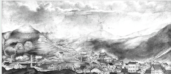
The industrial centre of the Ramsbeck mining area, as it emerged in the middle of the 19th century and remained until well into the 20th century, is shown to us in the lithograph above. Created around 1860 by an artist from Aachen, it gives us an overall detailed picture: In the left foreground a high mountain cone, on the right a mountain ridge stretches from south to north, in between an elongated valley in which the rows of houses finally lose themselves in the background. On the right, houses of the „Werdern“, below, the course of the river Valme can be seen with the complex of the machine foundry adjoining on the right and the so-called water castle, which was built over the river bed due to lack of space. The ruins of the second planned moated castle were later demolished. The house of the mine directorate stands on the slope to the right, with two turrets, a window front and an arched portal. On the left, opposite, are the loading and smelting facilities. A little further north is the residential house with the tower clock on the roof.
Dominating the foreground are the buildings of the stamping works and the smelters, which are highlighted in more detail: Large halls with smoking chimneys whose architecture has been preserved to this day in the remaining remnants of the old workshop. The Bastenberg rises conically in front of us. The spiral-like stripes on the hillside indicate the spoil heaps. There are no trees. We also recognise small houses standing on rubble heaps. They were often located near the adit mouth holes and belonged to the processing plants. The dew was separated by hand from the ore-bearing rock immediately in front of the mouth holes in order to obtain the necessary fall terrain for transporting the ore products. The fall terrain was used by a kind of viaduct over which the separated ores were transported down to the valley. Here they were then smelted or further processed in the roasting and smelting plants. In Ramsbeck, only lead ores came into question for this purpose.
The cutting work took place during the summer months; during the winter the ores were set, washed and rewashed.
It is clear from the lithograph that mining took place more on the outskirts of the village, the Werdern area thus formed a district in itself, the centre of the village remained rural. The picture shows us how the mountainous landscape of the Bastenberg is completely changed. Nature is no longer seen as an area in its own right, but is adapted to meet the needs of mining. The Bastenberg is directly connected to the industrial plants. We see smoking chimneys in the valley; clearly visible is the chimney on the slope from which the toxic gases of the Ramsbeck smelter escape. The natural landscape has become an industrial landscape. Mining and industry determine the scenery of the picture. The residential houses, on the other hand, are insignificant peripheral phenomena. Mining on the Bastenberg ended in 1912. The focus then shifted to Dörnberg.
The Industrial Revolution in Germany changed traditional and familiar living conditions, altered towns, villages and landscapes. The lithograph therefore gives a clear picture of the industrial awakening of the Ramsbeck mining industry.
Photo from around 1910
The representative building for the mine directorate, which still stands today, was built on an elevated site in 1854. Like a stately residence, it stood out clearly from the surrounding industrial buildings and residential houses. The three-storey, angular building is built into the hillside. In 1928 it was given a winter garden and was modernised as an administrative building in 1952/53. A new residential building was built next door for the mine manager in 1949.
.
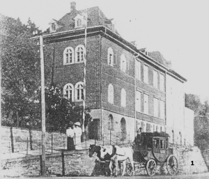
Photo from 1950
The single-storey half-timbered building with the four protruding gables housed the horses for the transport of goods and for the carriages. This horse stable was diagonally opposite the head office on the other side of the street. When the horse-drawn carriages were gradually replaced by tractors and automobiles, the horse stables were converted into garages. The building was demolished in the 1950s.
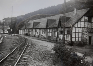
Photo from 1950
Below the director’s building, the view fell on an apartment building that was also built during the „French period“ in 1854. It stood in the midst of the industrial complexes; the high windows dividing the slated wall surface are striking. The tower clock on the roof served not only as decoration, but also as a reminder to the employees and workers to start and end their shifts on time. The house was later demolished. – At right angles to it stands an elongated house. It first served as a magazine, then a „Konsum“ was set up here where the employees could buy food. Since 1941 it has been used as a residential building by the employees of the Stolberger Zink AG. Like several other buildings, it is now a listed building.
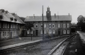
Photo from before 1907
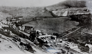
A few metres to the north, the view falls on the former silver smelter with the four chimneys, built in 1854. In the square on the left, there is a residential building, which also housed a home for the elderly for a time, along with the former public smokehouse at right angles and, facing the street, the hospital built in 1880 (today a patient care facility), in which the Franciscan Sisters of Olpe provided nursing services under the direction of the Ramsbeck doctor. The entire complex shows that the working and living areas were directly related to each other; both were functionally connected. The large kitchen gardens, which spread out on the right side of the slope, close to the industrial facilities, were an indispensable source of nutrition for the miners, and are therefore not without significance for the living conditions as a whole.